I suppose it’s appropriate that we have severe weather this weekend (if in fact we do), given that (1) I wrote Friday about breaking news, the most common of which here is severe weather, and (2) Severe Weather Awareness Week runs Monday through Friday.
So, yes, if we have storm warnings Sunday, they will be issued before Wisconsin’s official Severe Weather Awareness Week. That happens every few years, including last year, and Jan. 7, 2008. (The latter was a strange way for Mother Nature to celebrate my parents’ 47th wedding anniversary, given that neither my parents are from southeast Wisconsin.)
Weather, specifically severe weather, is a favorite subject of this blog. On this blog and the predecessor blog, I tried to write an annual severe weather blog about the time the first severe weather of the season was predicted. Last year featured three Ripon-area tornado warnings, the second of which gave French students their first taste of Wisconsin severe weather, and the last of which trapped us in the basement of the Ripon Public Library.
Of course, the weather has been known to change in this state and fail weather predictions. (Consider the Accuweather-forecasted highs for next week: 75 Sunday, 49 Monday, 55 Tuesday, 63 Wednesday, 56 Thursday, 57 Friday, 55 Saturday. The term “normal Wisconsin weather” is either an oxymoron or such a general term as to mean nothing. Tornadoes have occurred in every month except February, and measurable snow has fallen every month except June, July and August.) So if this fizzles out, well, you’ve gotten a preview of Severe Weather Awareness Week two days early. But weather predictions have gotten better over the years.
In addition to the National Weather Service’s Milwaukee — I mean, Sullivan, or is it Dousman? — and Green Bay — I mean, Ashwaubenon — Web and Facebook pages (because we’re in the middle of the two), I also follow Meteorological Musings, which is USWeatherExpert on Twitter. Mike Smith is the author of one of my favorite weather books, Warnings: The True Story of How Science Tamed the Weather. (Not that it’s pertinent to this, but Smith and Joe Bastardi of WeatherBell Analytics, who I also follow on Twitter, have the correct scientific perspective about man-caused global warming.)
Hype, panic and fear are never called for. Merely because you should do this at some point anyway, it would be useful to check to see if the gutters from your house roof are correctly connected so they don’t drain into your basement, make sure the batteries in your weather radio are fresh, find a non-electric-powered radio and a couple flashlights that actually work, and then clear the path to the central room in the lowest floor of your house. (And if you work at a radio station that normally doesn’t have anyone there on weekends, plan to have someone there tonight and/or Sunday.) And, if you have a cellphone whose battery power is measured in minutes, not hours, charge your cellphone too.
If something is worth updating, I’ll update this blog later today or Sunday.
Sunday update: The worst severe weather threat seems to have shifted a bit west, as shown by the Storm Prediction Center’s maps for general severe weather …
… tornadoes …
… high winds …
… and hail:
Sunday 8 p.m. update: Despite what the weather is doing (not much here), the weather types are pretty much sticking to their severe weather story:
The sudden onset of almost summer-like weather earlier this week (and this weekend), along with the weather that produced 63 tornadoes to the south but snow here March 2, and this being National Severe Weather Preparedness Week bring this item to mind, from meteorologist Mike Smith:
Starting April 1, in the geographic areas served by the National Weather Service offices in Kansas City, Wichita, Topeka, Kansas City, Springfield (MO), and St. Louis there will be multi-tiered severe thunderstorm and tornado warnings.
The changes which I will describe below spring from the high death toll from U.S. tornadoes in general, and the Joplin tornado in particular, in 2011.
The Joplin tornado May 22, 2011, an EF5 on the Enhanced Fujita scale of tornado damage, killed 160, injured more than 990, and caused an estimated $2.2 billion in damage.
To review for non-weather-geek readers: A tornado warning (three of which were issued for the Ripon area in 2011, a personal record since Dane County in 1984, the year of the killer Barneveld tornado) is issued when a tornado or funnel cloud is sighted by trained tornado spotters, a tornado is indicated by weather radar, or weather radar detects a severe thunderstorm capable of producing a tornado (or STCOPATs as I call them).
To expand upon that, the Weather Service in a few Kansas and Missouri offices will be able to issue two augmented warnings:
A Particularly Dangerous Situation tornado warning. (Similar to a PDS Tornado Watch, issued when “long-lived, strong and violent tornadoes are possible,” such as EF4 or EF5 tornadoes. There is also a PDS Severe Thunderstorm Watch (for winds around 90 mph or 1.5-inch hail) and Flash Flood Watch, but they have never been issued in this state.)
A Tornado Emergency, which is now issued for large tornadoes heading toward populated areas. Twelve Tornado Emergencies were issued during the March 2 outbreak.
What’s the problem here? Says Smith, author of the fascinating Warnings: The True Story of How Science Tamed the Weather:
Unfortunately, they are going to allow a sentence to be added to severe thunderstorm warnings that states, “A tornado is possible.” What do you or a school principal do with that? Go halfway down the basement stairs?
Given the political pressure the National Weather Service seems to be under at the moment, I forecast that many severe thunderstorm warnings will contain that unfortunate sentence and the “overwarning” problem, which we know causes complacency, will get measurably worse. …
The first problem is that the science does not exist to do this! We have no skill at short-term tornado strength forecasting. None.
Second, who is going to be able to keep straight whether a “tornado emergency” is better or worse than a “particularly dangerous situation”?
Third, even if #1 and #2 were not issues, what do you want the public to do differently?! Since we meteorologists want everyone to take shelter during a tornado warning, the two “tornado warnings on steroids” are superfluous. …
This isn’t just my opinion. Dr. Laura Myers, a social scientist at Mississippi State University, wrote yesterday,
My conclusion: It would seem that more detail and more warning levels would help, but I think it just leads to confusion and [warning] fatigue.
When a tornado is bearing down, people need to act and act quickly. Having to think through warning types is counterproductive.
Two comments explain both the Weather Service’s rationale, and why they may be wrong:
I suspect that the experiment in question is driven by a conviction that lack of an enhanced warning or tornado emergency message was a reason, or perhaps THE reason, so many died in Joplin, therefore, an ironclad policy on issuing tornado emergencies will prevent that from ever happening again. If that is so, it would be a classic case of “not seeing the forest for the trees.”
If warning fatigue and lack of visibility of the actual tornado were primary contributing factors to the Joplin death toll, then all the super duper enhanced warning language in the world probably wouldn’t have made much difference.
Yeah, but …
No, it’s exactly the opposite. … The reason most people didn’t react to the warning until it was too late was because they have had two dozen tornado warnings in the past 3 years, and none resulted in a tornado.
And to expand:
The general consensus of the public at large is that most warnings are for some place else. The town where I live has had approximately 10 tornado warning over the last 6 years, out of those 10 only 2 were of any threat to my house. By threat I mean the my town was in the path of the storm. Now all of the warnings were valid for the areas issued. However only 20% even included my area. There are places within my county where over the past 6 years that no warnings were valid, but they were warned just the same. The invalid warning messages being sent are desensitizing the warning message.
There are many competent Sociological, and Psychological studies on warnings, and experts in the field who could help in this matter. Almost all would state that a focused, accurate, and direct warning will work better than a complex, wordy, inaccurate, and irrelevant one. This does not take a PhD in Sociology to understand, as it is a common daily occurrence.
The people in Joplin were in their cars, away from home and out and about because the warnings had become meaningless. If you read the response from the victims, almost all to a person stated that they would not take cover till they saw the storm. Why was that? They had been trained to do so by sitting in their shelters for a storm that was 20 mi to the NE moving away from them. They wasted time sheltering from a storm that was no threat to them. So at that fateful day they did not heed the warnings, used the past training as given by the system, and many died because of it. Also, this was an extremely violent storm, one difficult to survive even with the best of shelters.
That last sentence is the meteorological equivalent of the law-school phrase that good cases make bad law. EF5 tornadoes have wind speeds beyond 200 mph. (Wisconsin has had three — in Colfax June 4, 1958, with 20 killed; in Barneveld June 7, 1984, with seven killed; and in Oakfield July 18, 1996, with none killed. Five other Wisconsin tornadoes before the Fujita scale was created, including the New Richmond tornado of 1899 that killed 117, are estimated to have been EF5s as well.)
My contention for a few years has been that the STCOPAT warnings are not helpful because they lead to more tornado warnings without actual tornadoes, which lead to ignored tornado warnings. A tornado did actually occur during the third tornado warning last year, which was issued while we were at the Ripon library. My wife, who went through the same tornado spotter training as I did, was driving into Ripon at the time, and didn’t see anything that looked like a tornado at the same time a tornado was causing damage to a farm outside Ripon. The 2010 tornado season started east of Green Lake, and before that in June 2004 a tornado sucked a couple out of their basement near Markesan, killing the man and severely injuring the woman. And that’s been it in 13 years of living in Ripon, which has certainly had more than five tornado warnings in that time.
Wisconsin doesn’t have as many tornadoes as the main parts of Tornado Alley, but we have enough that cause enough damage to make improving how the National Weather Service warns about tornadoes important. If terminology can be improved, that should save lives and prevent injuries. But accuracy is more important. And the Weather Service still issues too many warnings for tornadoes that don’t occur (at least as far as those in the warned area consider) that makes expanding the number of tornado warnings seem like change instead of proress.
Today’s weather notwithstanding, let’s hope AccuWeather doesn’t live up to its prediction:
The AccuWeather.com Long-Range Forecasting Team is predicting another brutally cold and snowy winter for a large part of the country, thanks in large part to La Niña… yet again.
La Niña, a phenomenon that occurs when sea surface temperatures across the equatorial central and eastern Pacific are below normal, is what made last year’s winter so awful for the Midwest and Northeast. Monster blizzards virtually shut down the cities of New York and Chicago. Last winter was one of New York City’s snowiest on record.
The way the jet stream is expected to be positioned during this winter’s La Niña will tend to drive storms through the Midwest and Great Lakes. Last year, the jet stream steered storms farther east along the Northeast coast, hammering the Interstate 95 corridor.
Therefore, instead of New York City enduring the worst of winter this year, it will likely be Chicago.
The division of The Weather Channel that handles long-range forecasting has similarly sad news:
WSI (Weather Services International) expects the upcoming period (December-February) to average colder than normal across most of the northern and western US, with above-normal temperatures confined to the and south-central and southeastern states. The WSI seasonal outlooks now reference a standard 30-year normal (1981-2010).
“So far, November has been fairly mild across the major energy demand centers of the US. While no short-term change to this pattern is expected, we do foresee a trend towards colder temperatures across much of the northern US, including the Midwest and Northeast, in December,” said WSI Chief Meteorologist Dr. Todd Crawford. “The winter pattern will be dominated by the current La Nina event, which favors below-normal temperatures across the northern US and above-normal temperatures across most of the South. … For the December-February aggregate period, we still feel that slightly below-normal temperatures will occur north of a Denver-Philadelphia line and across all of the western US. …”
What about the weather forecasters paid for by our tax dollars? The next maps are the National Weather Service’s predictions for, in order, temperature (blue is below-normal and orange is above-normal) and precipitation (green is above-normal and brown is below-normal) for December …
… December through February …
… and January through March:
Aren’t you happy that meteorologists have come together to decide that our winter is going to suck once again? Of course, given that there’s a large snow pile across the street, which has been there since earlier this month, we shouldn’t be surprised. One wonders what the hell was in the minds of our ancestors who thought it was a great idea to come to a part of the country whose winters feature temperatures cold enough to kill you and snowfalls deep enough to kill you during snow removal or from crashes caused by said snowfalls.
Today at 1 p.m., for 30 seconds every TV station and cable channel will broadcast a test of the Emergency Alert System.
The test will not sound like this:
The test is a first because there has never been a nationwide test of the Emergency Alert System or its predecessor Emergency Broadcast System.
For that matter, the EAS has never been activated for a nationwide emergency. That includes 9/11, the Cuban Missile Crisis, the Berlin Wall crisis, the assassination of John F. Kennedy, or any other national event, including this event 46 years ago today:
It may seem like an obvious thing to have issued a nationwide EAS alert on 9/11. But what good would it have really done? It would not have been issued before the second plane hit the World Trade Center at the earliest, and by then the plot involving the two other planes was well under way. The federal government grounded every flight in the country. Issuing a nationwide EAS alert would have only generated more panic then the conclusions TV viewers were already drawing.
So what is the point of a nationwide test? According to an FCC news release, “The purpose of the test is to assess the reliability and effectiveness of the EAS as a public alert mechanism. EAS Participants currently participate in state-level monthly tests and local-level weekly tests, but no top-down review of the entire system has ever been undertaken. The Commission, along with the Federal Emergency Management Agency, will use the results of this nationwide test to assess the reliability and effectiveness of the EAS as a public alert mechanism, and will work together with EAS stakeholders to make improvements to the system as appropriate.”
The chief of the FCC’s Public Safety and Homeland Security Bureau adds:
Early warnings save lives. This was demonstrated recently and dramatically during the major earthquake and tsunami that devastated Eastern Japan. Except for Japan’s early warning systems, loss of life would have been much higher. …
Although FCC rules require local and state components of the EAS to be tested on a weekly and monthly basis, the system has never been tested nationally end-to-end. If public safety officials need to send an alert or warning to a large region of the United States, in the case of a major earth quake and tsunami on the West Coast, for example, or even to the entire country, we need to know that the system will work as intended. Only a top-down, simultaneous test of all components of the EAS can tell us this.
Early warnings do save lives, but only if they’re heeded. The National Weather Service issued this apocalyptic (as described by the narrator) warning before Hurricane Katrina, which was not heeded by tens of thousands of New Orleans residents:
Part of the reason, as I’ve discussed beforein this space, is that the National Weather Service issues more tornado warnings than they used to,which means more ignored tornado warnings. In the past, tornado warnings would be issued upon visual (by weather spotters, usually law enforcement) or radar evidence (the “hook echo”). For several years, the NWS has been issuing what I call STCOPAT warnings, for a “severe thunderstorm capable of producing a tornado.” (We had a personal record three visits to the basement this year, one toward the end of our German/French/Italian foreign exchange student’s visit, and another during a Story Time visit to the Ripon library.)
There have been a handful of false emergency alarms of a non-meteorological nature. Imagine yourself listening to the radio in Fort Wayne, Ind., on a Saturday morning in February 1971, when you hear this:
In June 2007, something similar happened in Illinois:
Today’s test originally was going to take 2½ minutes, but was shortened to 30 seconds. As TV Technology puts it, the Federal Emergency Management Agency “confirmed the shortening of the Nov. 9 test, but did not say specifically if the agency did so to reduce the chance of an unintended reenactment of ‘War of the Worlds.’ The change was said to be made at the direction of Secretary of Homeland Security Janet Napolitano.”
I’m guessing the test was shortened to 30 seconds because of, shall we say, negative reactions. First, from The Blaze:
Only the President has the authority to activate EAS at the national level, and he has delegated that authority to the Director of FEMA. The test will be conducted jointly by the Department of Homeland Security (DHS) through FEMA, the Federal Communications Commission (FCC), and the National Oceanic and Atmospheric Administration’s (NOAA) National Weather Service (NWS).
In essence, the authority to seize control of all television and civilian communication has been asserted by the executive branch and handed to a government agency. …
So this begs the question: is the first ever national EAS test really a big deal?
Probably not. At least, not yet.
But there are some troubling factors all coming together right now that could conceivably trigger a real usage of the EAS system in the not too distant future. A European financial collapse could bring down U.S. markets. What is now the “Occupy” movement could lead to widespread civil unrest. And there are ominous signs that radical groups such as Anonymous will attempt something major on November 5th- Guy Fawke’s day.
Now we know in the event of a major crisis, the American people will be told with one voice, at the same time, about an emergency.
All thats left to determine is who will have control of the EAS when that day comes, and what their message will be.
I can’t see a legitimate need to cut off radio and TV in an emergency.
Quite the opposite in fact.
Of all the Presidents this one is least trusted to have such control at his fingertips. This is not good news. what will we do when all radio and television communications cease, in the event of some type of emergency? I understand there possibly could be a time it is useful. Now the programs make announcements and run bulletins and banners across the screen. This is a great deal of power for one person to hold. How would we know what is going on if it happens that all communications were to cease for a time? … we would not know the cause or purpose. Not a good situation. This happened in Germany prior/during WW11
… Like I’ve said before, there hasn’t ever been a nation-wide test of the system. Now, you could say we sort-of had one in 1971 when the idiot operator at NORAD sent the wrong message during a weekly test. If you look at the results of what happened, then the system failed miserably. Over half the country would not have known if we were under attack. This is a way for the FCC to gauge how (and if) the system will work and to take steps to fix what doesn’t.
Now, something I didn’t know…the EAS is basically a last-ditch effort to get a Presidential message out to the people, just in case the President couldn’t use the networks to talk to us.
There are some who will view this as a way for Barry the Boob to prepare to put us under martial law, but I don’t look at it as something so sinister. It really is a good idea to do this…just to make sure it works. And if in some future time he does use it to do just that, then you can say “I told you so”.
It says something about the level of distrust in the federal government and the president that a seemingly worthwhile test has sinister overtones. Then again, the term “homeland security” is rather 1984-esque. And one should be skeptical about a government agency (and I could stop the sentence right there) for its color-coded contribution to national security.
The better question to me is what nationwide value the EAS actually has. In case of natural disaster, there’s no question. But natural disasters are local in scope. Should the U.S. be subject to, say, an electromagnetic pulse attack, no one will hear a presidential EAS message. We have news media that did as good a job as possible reporting the day of 9/11, and they would do the same in the event of an event of similar scope. Knocking every TV channel off the air for a presidential message, regardless of who the president is, seems to me to be counterproductive. In an actual emergency, less communication is not better.
Earlier today the National Weather Service suggested the chance of severe weather, including tornadoes.
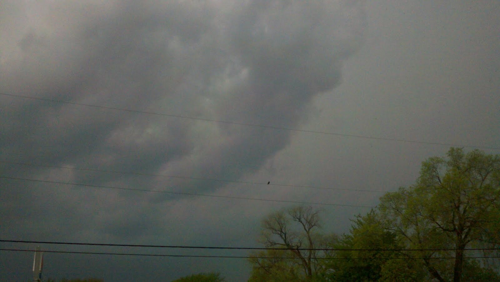
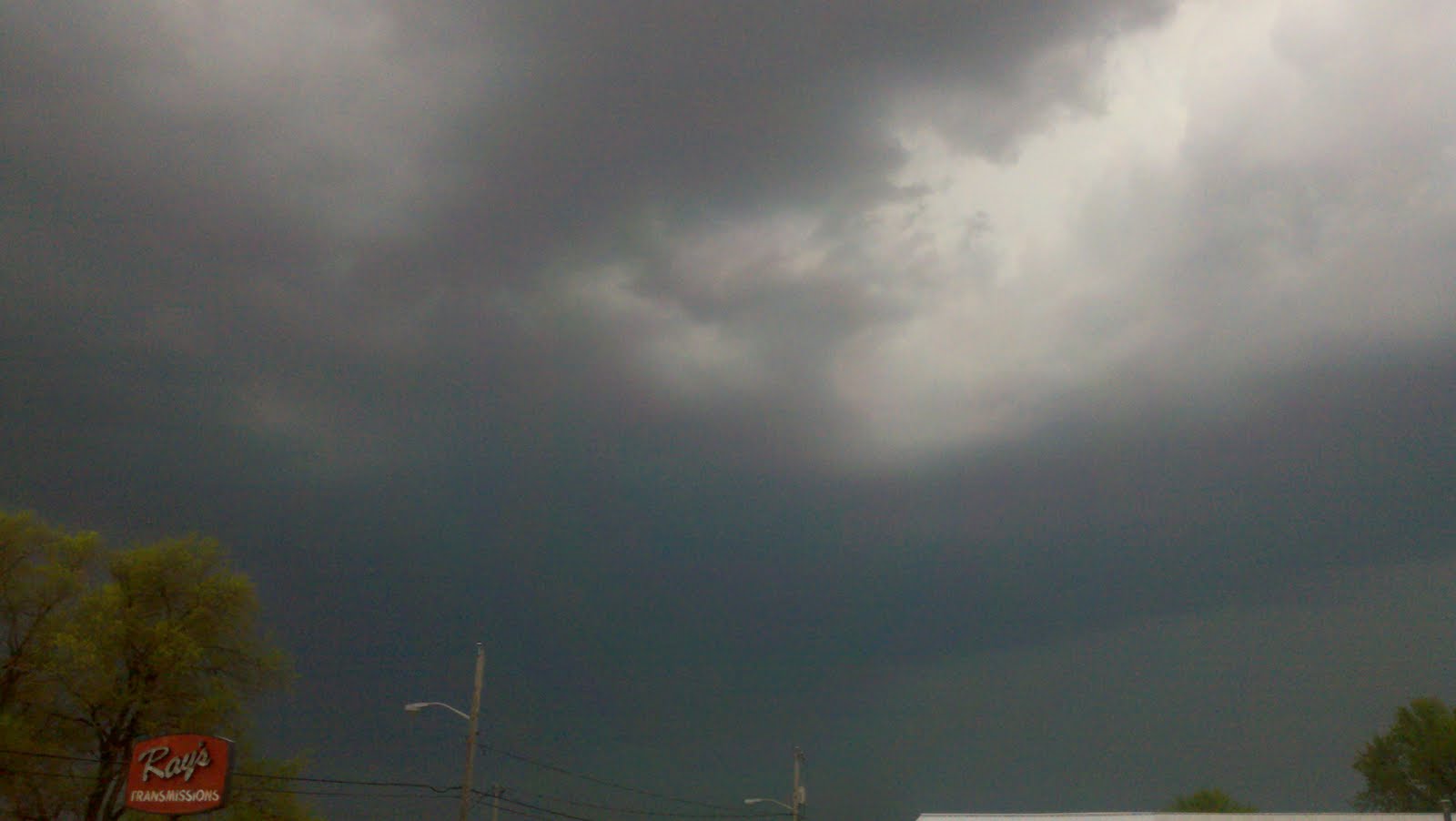
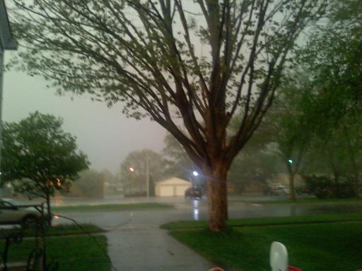
The first wave of storms came this afternoon, with (as photographed by Erica Dakins) storms well north of Ripon:
So we went to Cedar Ridge Ranch for the farewell party, where food was eaten, horses were observed and video was shot for the next Ripon Channel Report (coming to a TV near you if you’re a Charter Cable subscriber in the Ripon area).
We had been home not one minute when our weather radio went off to report:
THE NATIONAL WEATHER SERVICE IN SULLIVAN HAS ISSUED A * TORNADO WARNING FOR… NORTHWESTERN FOND DU LAC COUNTY IN EAST CENTRAL WISCONSIN… SOUTHERN GREEN LAKE COUNTY IN SOUTH CENTRAL WISCONSIN… * UNTIL 830 PM CDT * AT 742 PM CDT…NATIONAL WEATHER SERVICE DOPPLER RADAR INDICATED A SEVERE THUNDERSTORM CAPABLE OF PRODUCING A TORNADO. THIS DANGEROUS STORM WAS LOCATED NEAR MARKESAN…OR 15 MILES SOUTHWEST OF RIPON… AND MOVING NORTHEAST AT 45 MPH. * THIS TORNADIC STORM WILL BE NEAR… GREEN LAKE AROUND 755 PM CDT. RIPON AROUND 805 PM CDT. ROSENDALE AROUND 810 PM CDT.
So at least at the Prestegard house our French Adventure guest got to see what Americans who live in or near Tornado Alley do in tornado warnings: Head to the basement.
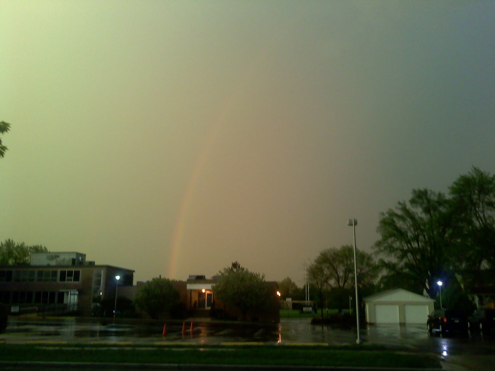
The storm went south and east of Ripon. If there was a tornado (and someone from Markesan apparently called the Green Lake County Sheriff’s Department to report a tornado going over his house), it missed here.
But at least we got to see a rainbow (which you can only sort of see in this photo):
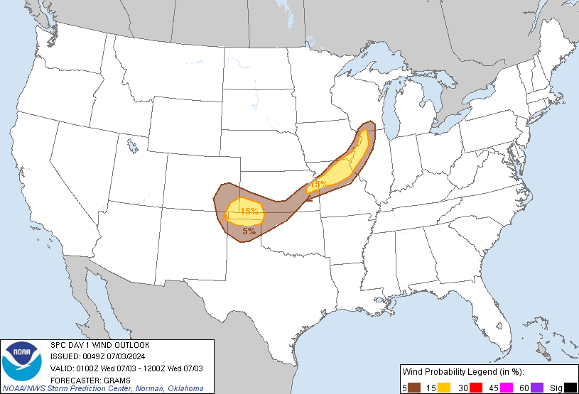
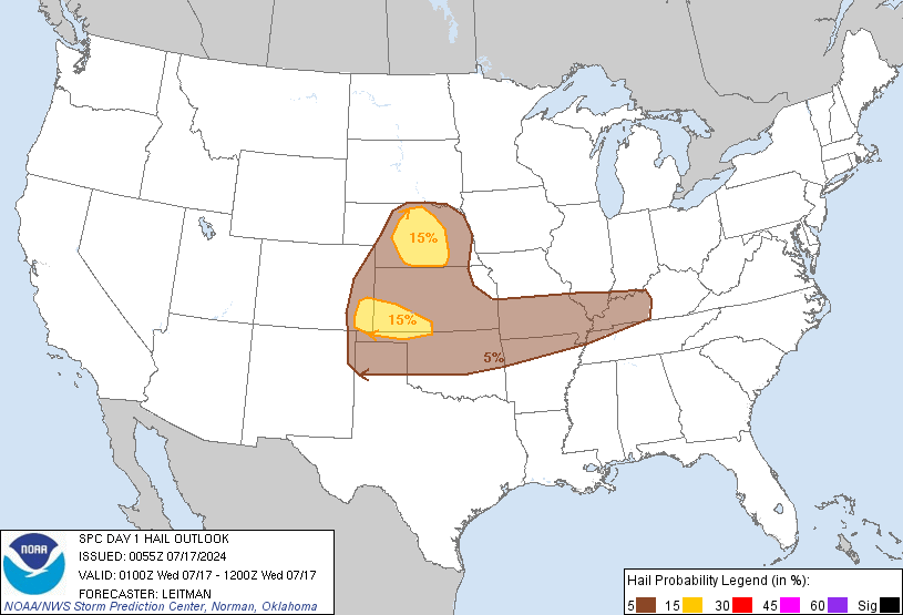
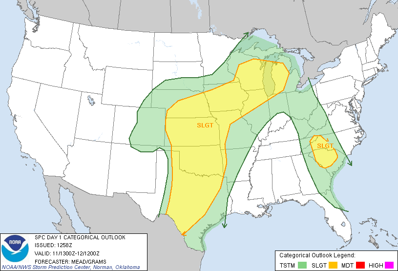
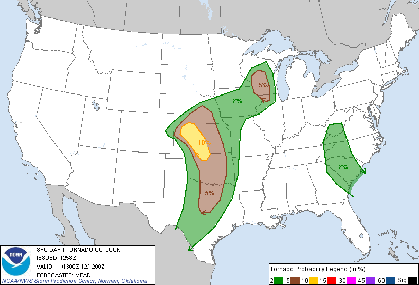
The National Weather Service Storm Prediction Center just posted these, shall we say, interesting looking maps for today:
The first map shows a 15 percent probability for the component parts of severe weather, high winds (50 knots, or 55 mph) and hail of 1 inch or larger. The second map shows a 5 percent probability for tornadoes, which doesn’t seem like much, but in meteorology (and in math, duh), 5 percent is more than zero.
For what it’s worth, AccuWeather thinks the threat will be slightly south of here:
But the Weather Channel thinks the entire state is at risk for severe weather today:
We’ll see who’s right. We may also find out how the hosts of French foreign exchange students explain to their guests why they have to go to the basement. (To answer the question in the headline, one online translator says it’s “avertissement de tornade,” which looks more like an advertisement for a tornado or an advisory for a tornado than a warning about a tornado.)
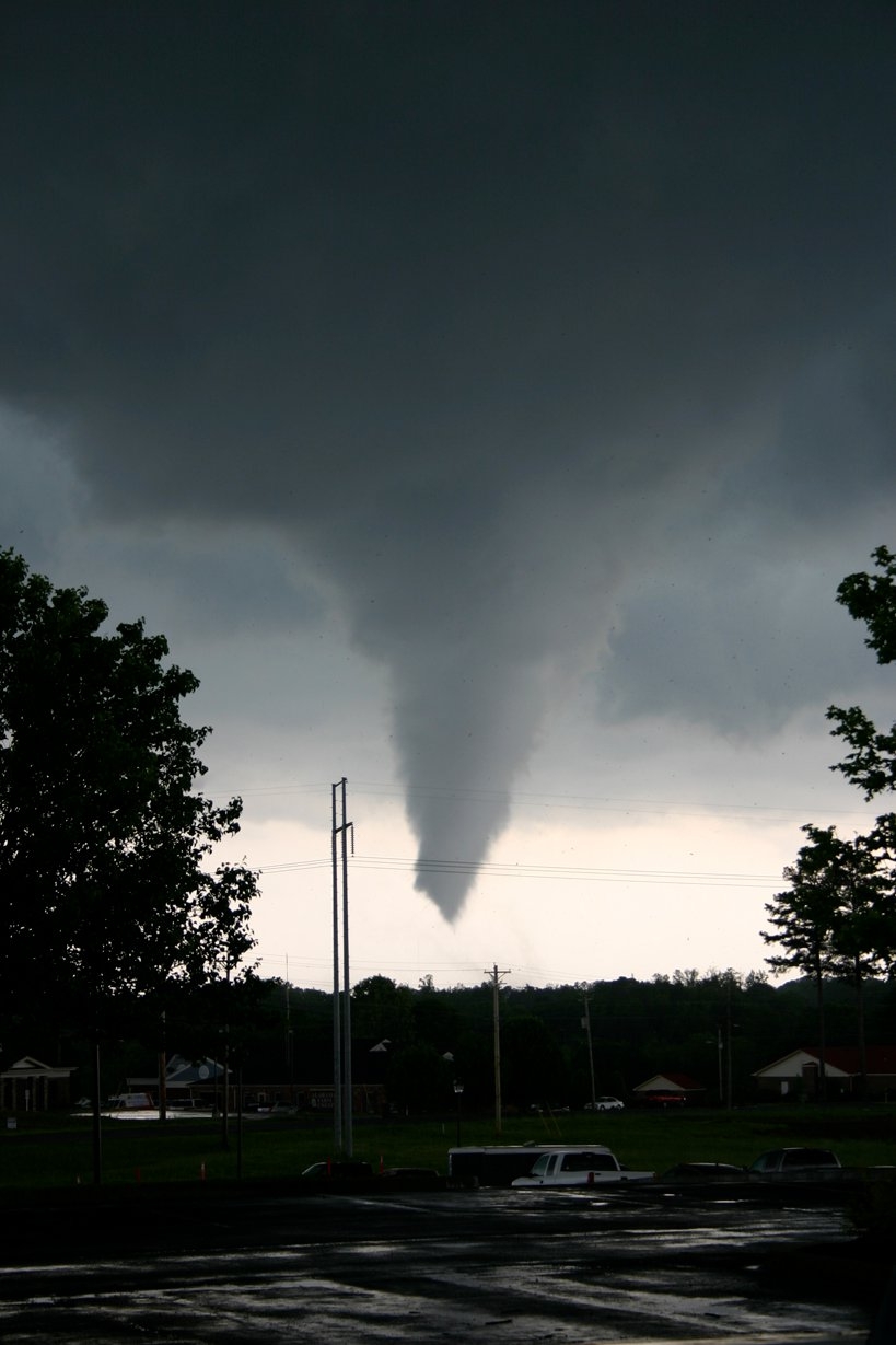
First, a photo from a friend of my wife, shot in Cullman, Ala.:
Next, the video that must be seen to be believed:
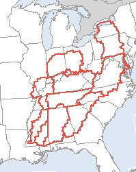
This shows the number of tornado watches that were in effect at 5:44 p.m. Central time Wednesday:
I followed the storm coverage from Birmingham and then Atlanta online Wednesday. As I tweeted, there were colors on the weather radar that I had never seen before, indicating the intensity of some of the storms.
With final death tolls still to be determined, this is being reported as the second deadliest tornado outbreak in U.S. history, passing up the April 1974 “Super Outbreak” (commemorated in the documentary “The Day of the Killer Tornadoes“), and exceeded only by the Tri-State Tornado (which probably was a series of tornadoes) March 18, 1925, among modern-measured tornado outbreaks.
The Meteorological Musings blog has a succinct explanation that may explain why so many people died Wednesday:
Here is some of what I believe is true, pending formal investigation.
This was a historic event. It appears (not sure yet) to be the worst tornado outbreak, in terms of number of F-4 and F-5 tornadoes (the upper 2% in damage potential) since April 3, 1974. It also appears similar to the “Enigma Outbreak” (same geographic area) of February, 1884. The latter is estimated to have killed as many as 1,200.
When dealing with F-4 and F-5 tornadoes, there is no assurance of survival. For example, in Greensburg, KS in 2007, eight of the 9 people killed (out of the 1,500 in the tornado’s path) were in shelter, including basements. The South has relatively few basements and many tens of thousands were in the path of these tornadoes. The bathtub offers reasonable protection for the far more common F-1 to F-3 tornadoes. It offers little protection during F-4 and F-5 tornadoes where everything is swept away.
Earlier tornadoes knocked out the communications infrastructure. This is a problem I have not previously encountered. It was first reported by a Birmingham TV station today. There are reports that because of the multiplicity of tornadoes, the power had been lost in the first wave of storms and so TV, internet, etc., were not available when the second wave occurred. These people likely did not get the warning. We do not yet know how widespread this problem was.
Mobile homes. We talked about this less than two weeks ago. I was in Charlotte a week ago today and was told by insurance industry people that the tie-down laws are not enforced (no requirement for inspection upon occupancy). I have seen video of mobile homes that were not tied down and were without wind skirting. They also told me few mobile home parks had shelters. If true, this is a deadly combination. In the April 15-16, 2011 tornadoes from Mississippi to North Carolina, 86% of the deaths were in mobile homes.
The “communications infrastructure” referred to in his third bullet point may have included, based on reports of last week, National Weather Service radio. A morning wave of severe weather not only knocked out power, but may have knocked down towers. This is critical given that weather radio gets out the warnings before media, since the warning is given by computer then automatically broadcast.
There are two additional potential factors; one is a fact, the other is conjecture. The 1974 outbreak was in a country that had less than 200 million people in it. Last week’s outbreak was in a country that has more than 300 million people, and the South has grown faster than most other parts of the country. All other things being equal, if areas are more dense people, the possibility for higher casualties increases.
From all indications, the warnings did in fact get out. (As they did during our tornadoes of early April.) Improved weather radar technology (in the 1974 outbreak, “weather radar” was World War II-surplus aviation radar) meant storms are easier to track, and their severity is more apparent. (And it certainly was apparent Wednesday night.)
One wonders, though, about, for lack of a better term, “warning fatigue.” Despite the fact that the Weather Service predicted our early April tornado outbreak several days in advance, there remains skepticism up here about storm warnings because everyone can remember at least one time when the Weather Service got it wrong. As noted here before, to the usual tornado-warning criteria of a radar signature or an actual sighting has been added what I call a “STCOPAT” — Severe Thunderstorm Capable of Producing a Tornado. (Such as the STCOPAT that sent us into our basement without a tornado actually occurring.) The South gets more tornadoes than here, so I can’t say if the South gets “warning fatigue,” but one wonders how many people were skeptical about the warnings until the weird-colored skies and the dreaded freight train sound, and by then it’s probably too late.
Another reason I like Meteorological Musings is because the blogger is correctly skeptical about another popularly attributed cause for last week’s severe weather: global warming — oops, anthropogenic climate change or whatever it’s being called these days. He quotes from (more accurately, tears apart) a New York Times story:
The Times’ article begins with this statement:
The cruelty of this particular April, in the number of tornadoes recorded, is without equal in the United States.
This may or may not be true. The statement is at least premature. The NWS Storm Prediction Center March 8th changed its methodology which allows more reports of tornadoes and other severe storms to be logged (see first note here). We don’t know yet whether this is a record April.
Tornadoes in particular, researchers say, straddle the line between the known and the profoundly unknowable.
It is correct that we do not fully understand the physics of tornadogenesis but we understand the conditions under which large tornadoes (like Wednesday’s) form so we can forecast them and issue warnings for them with high accuracy. If you don’t believe it, just scroll back through the forecasts of the last three weeks on this blog or, for Wednesday’s storms go here or here for just two examples. It is hardly a “crapshoot.” …
The next paragraphs are, I suspect, the real motivation for this article:
When technology can predict oncoming storm tracks and conditions with greater certainty than ever, and scientists assert with growing unanimity a human impact on climate, what is a natural act of God and what is more correctly the province of humans themselves? Where is the place of psychic shelter in an age when the lines between fate and human action are blurred?
The prevalence of hurricanes, droughts and floods has been linked in many climate models to the impact of a warming planet. Such a connection is more tentative when it comes to twisters.
Ah, ‘climate change.’ The article goes on to discuss the Times‘ linking of these tornadoes to climate change. This linkage can be easily refuted.
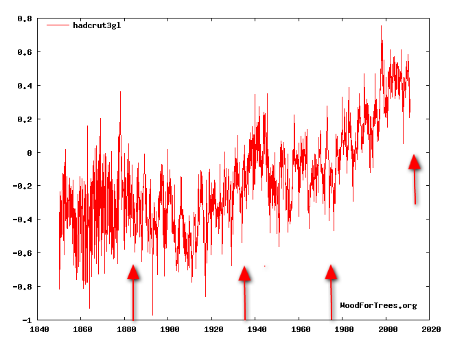
This is a graph of world temperatures complied by the University of East Anglia’s Climate Research Unit (global warming advocates). I have placed arrows pointing to the temperatures in 1884 (the “Enigma Outbreak” which killed as many as 1,200 in the South), the 1936 Tupelo/Gainesville tornadoes (which killed 800+), the “Superoutbreak” of tornadoes in 1974, and Wednesday’s. Note that these tornado outbreaks — which killed even more people — all occurred with cooler atmospheric temperatures. It is absurd to link Wednesday’s tornadoes to current world temperatures!
The article goes on to babble,
If scientists cannot be sure — or trusted, as doubters of climate change might say — then where should an ordinary person on the ground turn for solace or strength in the raging maw of a storm?
Can’t be “trusted”? As an atmospheric scientist, I resent this. Meteorologists have worked tirelessly over the last month to provide excellent forecasts and warnings of these storms that have been credited with having hundreds of lives.
Few publications can go off the rails like the Times when they want to find an excuse to write about‘climate change.’ It would be nice if, occasionally, they got their facts right.
But for the mainstream news media, which has thrown skepticism about the main cause and, more importantly, answers to global climate change that predates man and the Industrial Age (two words: Better adapt), facts get in the way of their story line.
That is the mainstream media’s excuse. There is no excuse for this:
ThinkProgress: Storm victims kind of had it coming, didn’t they?
The congressional delegations of these states — Alabama, Tennessee, Mississippi, Georgia, Virginia, and Kentucky — overwhelmingly voted to reject the science that polluting the climate is dangerous. They are deliberately ignoring the warnings from scientists.
Translation: ‘You know, it’s really awful what happened down there and all, but if you don’t believe in global warming, Gaia will end you.’
Thankfully, there is some pushback against this view from those in a position to know about such things, but I’m sure that opinion will be dismissed as heresy by the true believers. There’s a bloody shirt to wave, after all. Mankind must atone for its sins.
I do wonder, however, whether those who warn of the dangers of global warming realize that blaming all unusual weather on their favored boogeyman leaves them open to criticism like this. Just so you know, that isn’t the only post at the blog along these lines. JammieWearing Fool finds another.
Meteorological Musings also passes on information about how to help the tornado victims. Somehow, I doubt ThinkProgress fans (one of whom’s address is at 1600 Pennsylvania Ave. in Washington, D.C.) will contribute.
For the record, the first tornado of 2011 was 20 days before the first tornado of 2010 … and before the start of Tornado and Severe Weather Awareness Week.
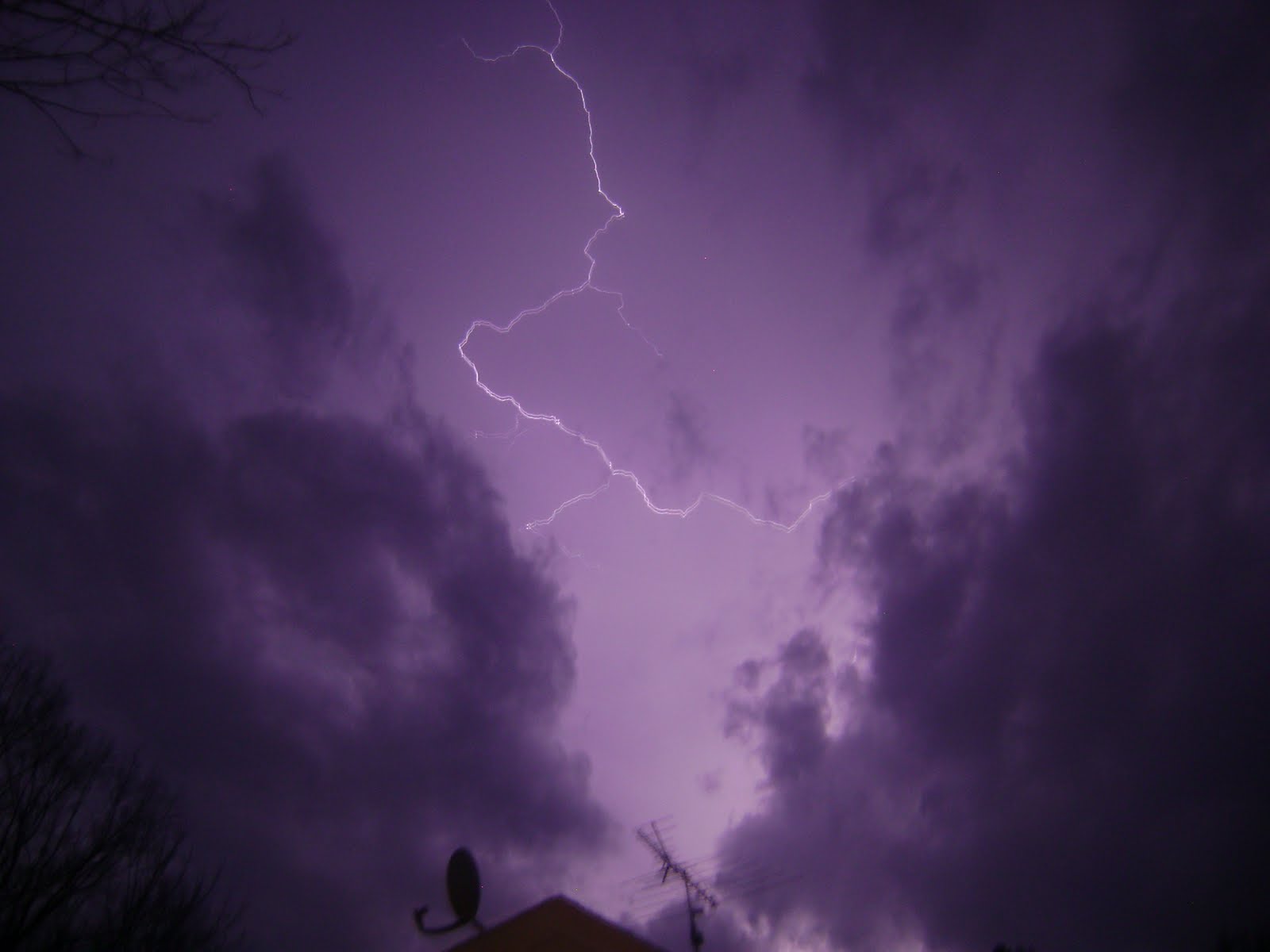
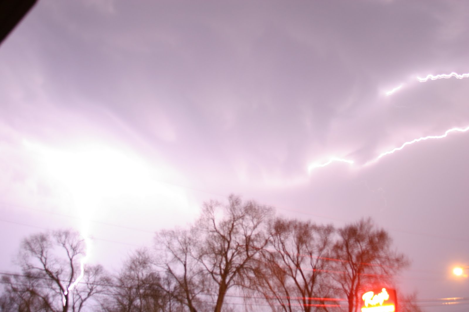
Not a bad lightning shot for a point-and-shoot. (Though there was little thunder in Ripon, there was continuous in-cloud lightning and rumbling to the north and northwest.) The bottom of the photo is the top of our house, so Jannan took this looking west.
Jannan’s camera does video!
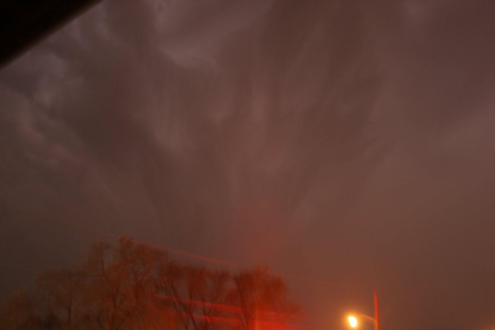
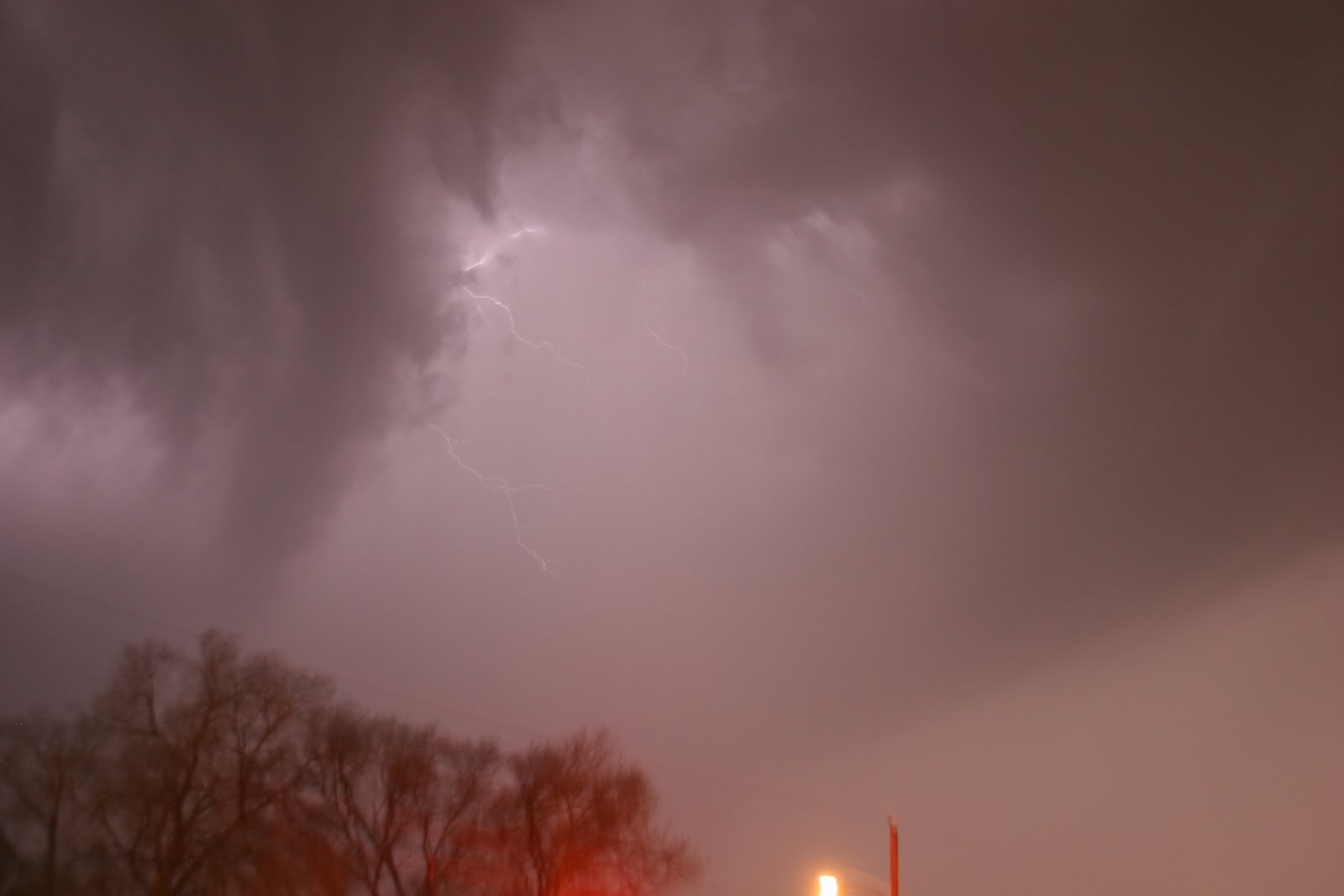
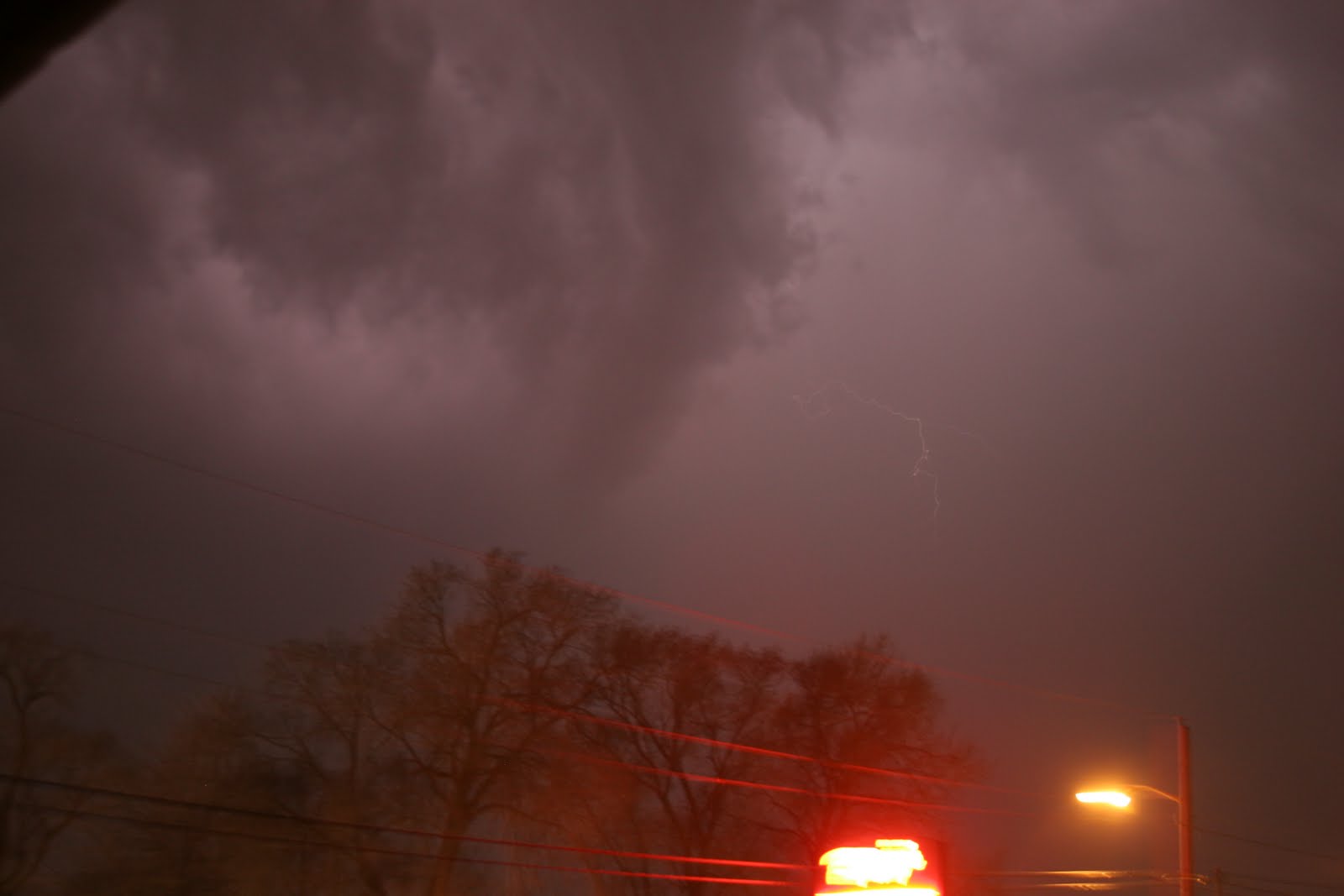
Meanwhile, to the north, Erica Dakins got these Stormageddon photos of lightning and downdrafts from Neenah: