I suppose it’s appropriate that we have severe weather this weekend (if in fact we do), given that (1) I wrote Friday about breaking news, the most common of which here is severe weather, and (2) Severe Weather Awareness Week runs Monday through Friday.
So, yes, if we have storm warnings Sunday, they will be issued before Wisconsin’s official Severe Weather Awareness Week. That happens every few years, including last year, and Jan. 7, 2008. (The latter was a strange way for Mother Nature to celebrate my parents’ 47th wedding anniversary, given that neither my parents are from southeast Wisconsin.)
Weather, specifically severe weather, is a favorite subject of this blog. On this blog and the predecessor blog, I tried to write an annual severe weather blog about the time the first severe weather of the season was predicted. Last year featured three Ripon-area tornado warnings, the second of which gave French students their first taste of Wisconsin severe weather, and the last of which trapped us in the basement of the Ripon Public Library.
The National Weather Service Storm Prediction Center severe weather forecast for the Plains states is apocalyptic, to say the least, today:

You need not be a meteorologist to know that being in a pink area is bad if you are in that pink area.
 Ditto the purple area or the hatched area in the tornado prediction map.
That is today; here is Sunday’s forecast, and notice where the red area is:

The National Weather Service’s Milwaukee office puts tonight and Sunday in graphic terms:


Of course, the weather has been known to change in this state and fail weather predictions. (Consider the Accuweather-forecasted highs for next week: 75 Sunday, 49 Monday, 55 Tuesday, 63 Wednesday, 56 Thursday, 57 Friday, 55 Saturday. The term “normal Wisconsin weather” is either an oxymoron or such a general term as to mean nothing. Tornadoes have occurred in every month except February, and measurable snow has fallen every month except June, July and August.) So if this fizzles out, well, you’ve gotten a preview of Severe Weather Awareness Week two days early. But weather predictions have gotten better over the years.
In addition to the National Weather Service’s Milwaukee — I mean, Sullivan, or is it Dousman? — and Green Bay — I mean, Ashwaubenon — Web and Facebook pages (because we’re in the middle of the two), I also follow Meteorological Musings, which is USWeatherExpert on Twitter. Mike Smith is the author of one of my favorite weather books, Warnings: The True Story of How Science Tamed the Weather. (Not that it’s pertinent to this, but Smith and Joe Bastardi of WeatherBell Analytics, who I also follow on Twitter, have the correct scientific perspective about man-caused global warming.)
Hype, panic and fear are never called for. Merely because you should do this at some point anyway, it would be useful to check to see if the gutters from your house roof are correctly connected so they don’t drain into your basement, make sure the batteries in your weather radio are fresh, find a non-electric-powered radio and a couple flashlights that actually work, and then clear the path to the central room in the lowest floor of your house. (And if you work at a radio station that normally doesn’t have anyone there on weekends, plan to have someone there tonight and/or Sunday.) And, if you have a cellphone whose battery power is measured in minutes, not hours, charge your cellphone too.
If something is worth updating, I’ll update this blog later today or Sunday.
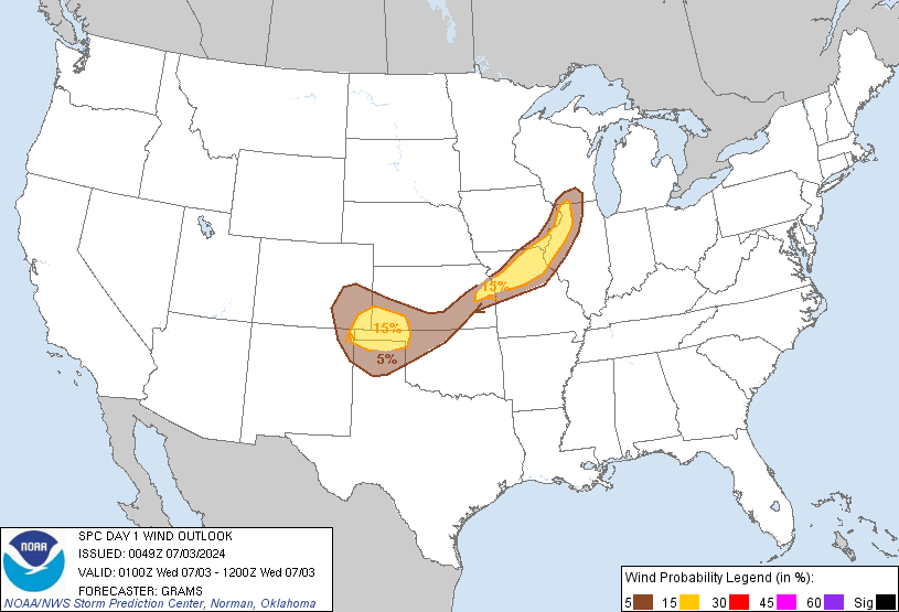
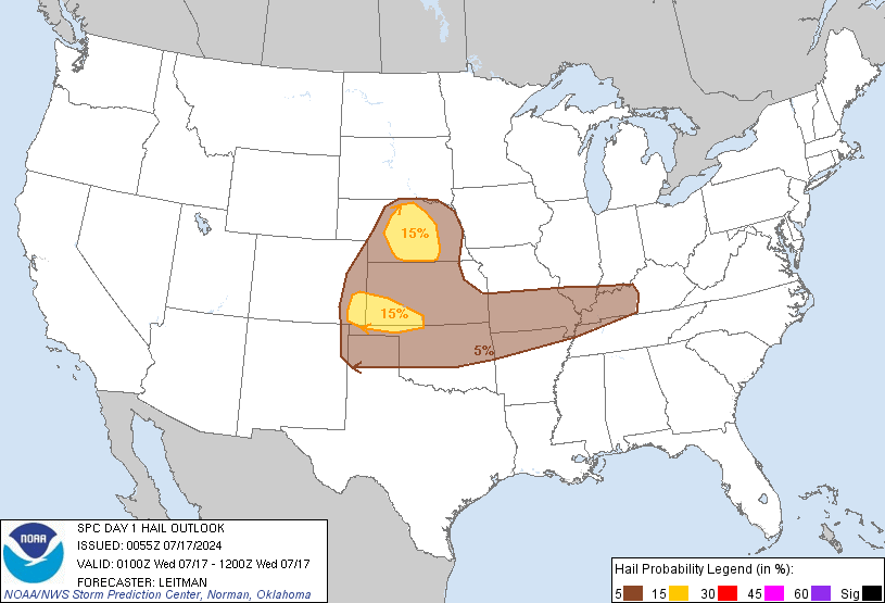
Sunday update: The worst severe weather threat seems to have shifted a bit west, as shown by the Storm Prediction Center’s maps for general severe weather …

… tornadoes …

… high winds …

… and hail:

Sunday 8 p.m. update: Despite what the weather is doing (not much here), the weather types are pretty much sticking to their severe weather story:


Leave a reply to More stormy weather predictions | The Presteblog Cancel reply