The Wisconsin statewide tornado drill is this afternoon, unless there is actual severe weather. (There are thunderstorms in the forecast, but probably not severe storms.)
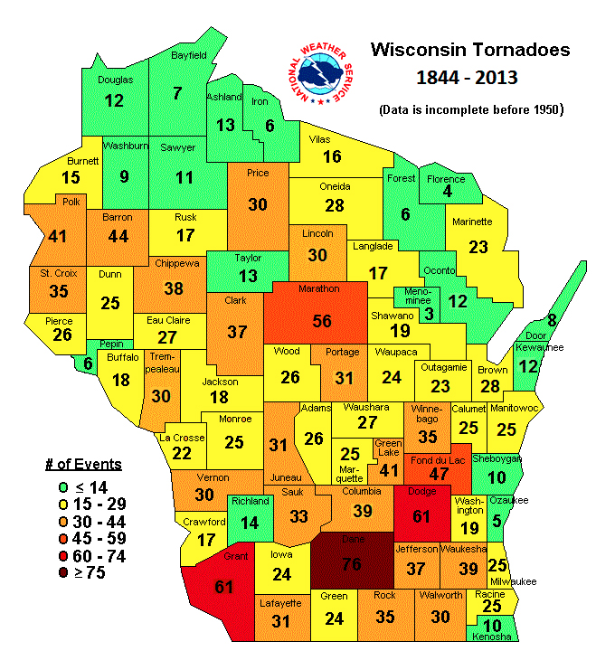
Regular readers know that I have a (yet another) strange interest in tornadoes and severe weather, perhaps because I’ve managed to live in almost all of Wisconsin’s Tornado Alley, such as it is, including the brown county and the three red counties in the bottom half of the map:
Though I have yet to see a tornado, I’ve spent time in a school basement during one tornado warning, did a UW journalism class story on the aftermath of the 1984 Barneveld tornado, had a tornado warning during UW Marching Band practice (the tubas helpfully started yelling “Auntie Em! Auntie Em! It’s a twister!”), lived where a tornado hit the afternoon before that evening’s tornado spotter training session (when, of course, it snowed), had an airline flight delayed by a tornado warning, live-blogged severe weather, observed the ugly clouds to the west that were part of the first tornado in the state that year (producing this classic video), showed our foreign-exchange student our basement for one tornado warning (a few days after he saw hail for the first time in his life), and, last year, broadcasted a high school baseball playoff game during a tornado warning, the weather that accompanied which forced a two-day delay in finishing the game. (The game was finished under, of course, a severe thunderstorm watch.)
The National Weather Service, which apparently is acronym-happy as are all units of government, is trying to improve its storm warnings by Forecasting a Continuum of Environmental Threats, or FACET, or maybe FACETs:
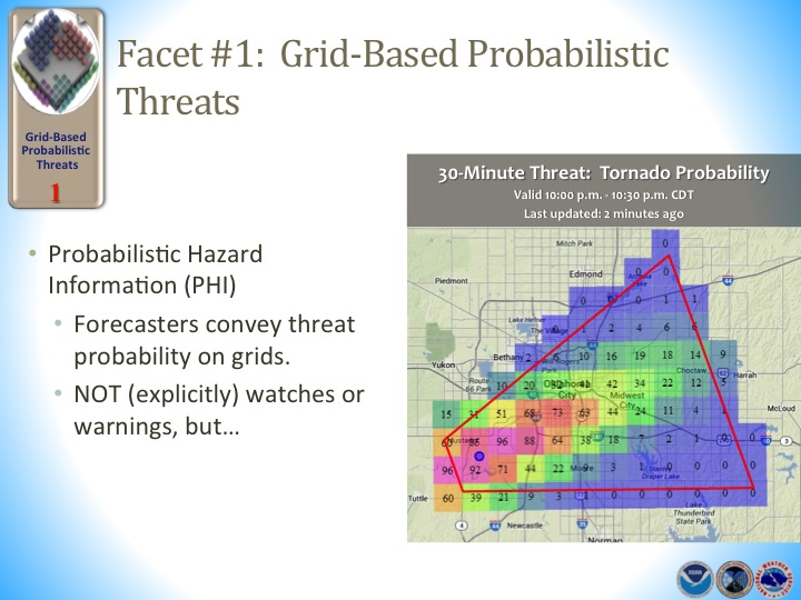
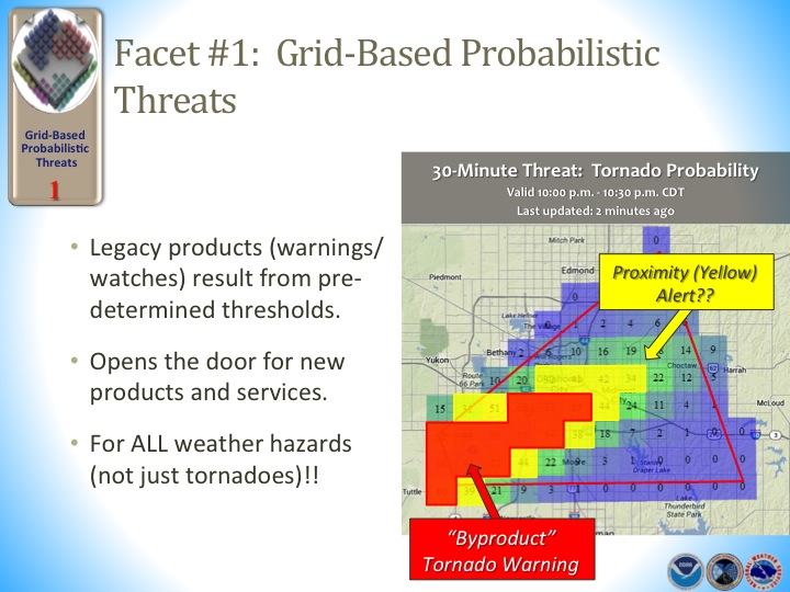
FACET #1 THREATS
FACETs will allow forecasters to improve upon standard weather watches and warnings by delivering detailed hazard information through the use of “threat grids” that are monitored and adjusted as new information becomes available.
Threat grids will be based on a rapidly updating high-resolution stream of weather information fed by current and future scientific tools. Forecasters can interpret and communicate weather threats along with the uncertainty associated with the predicted trend. Decision-makers requiring longer lead-times such as hospitals and large venues can set their own threat threshold based on their specific needs. Threat grids will also support the development of new products that address high impact but non-severe weather events such as lightning and strong winds that are below-severe limits.
FACET #2 OBSERVATIONS AND GUIDANCE
The FACETs framework will adjust to advances in satellite, radar and surface observation technology that already aid the forecasters’ decisions.
It will also introduce new computer-model predictions of storm-specific hazards such as tornadoes large hail, and extreme local rainfall from NOAA’s Warn-on-Forecast research project. Forecasters will receive real-time statistical projections of a storm’s longevity, intensity and hazards from NSSL’s database of climatological storm-scale behavior. FACETs intends for grid-based threat information to be linked from the NOAA Storm Prediction Center broad national and regional outlooks, watches and discussions, flowing downstream into local NOAA National Weather Service (NWS) forecast products and warning grids.
FACET #3: FORECASTER DECISIONS
Forecasters are essential to the warning process and they will be trained to understand use the new warning system. FACETs will also explore the decision-making process of the forecaster, how the public grasps the information, and ways the messages could be crafted so they respond safely. …
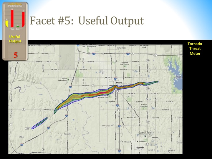
FACET #5: USEFUL OUTPUT
Under FACETs, the NWS will still issue legacy products such as watches and warnings, but their products will include more impact-specific information including urgency, confidence, and variability.
All grid-based threat forecast information would be easily transferable to various geographic formats to streamline and enhance decision support services.
FACET #6: EFFECTIVE RESPONSE
Forecasters cannot anticipate how many people are exposed to a threat and how they will respond if faced with one. FACETs will find ways to fine-tune threat output in a way that people will choose to implement their safety plan. Any progress made in the previous five facets would be for naught if peoples’ responses will be ineffective or wrong. This is where social and behavioral sciences integration will have the greatest impact, although contributions of these disciplines are essential in all facets of the threat forecasting process (see below). Likewise, FACETs development work will involve officials in emergency management, law enforcement, broadcast media, public health and other disciplines to ensure your response to hazardous weather is the most effective response. …
FACET BINDING: FULLY-INTEGRATED SOCIAL SCIENCE
Social science will strengthen the link between each facet. Anthropology, for example, might reveal important insights into the decision-making process of the forecaster or the education process of the public. Similar applications can be said of economics, human factors, sociology, communication, human geography, political science, linguistics, and law.
A few visual aids from the PowerPoint might be helpful:

It’s all interesting to weather geeks, with a couple of provisos. You should find rather creepy FACET 6, which wants to “find ways to fine-tune threat output in a way that people will choose to implement their safety plan,” as well as fully integrating “economics, human factors, sociology … political science, linguistics, and law.” So is the NWS going to try to make not going into your basement during a tornado warning illegal?
There is a quote toward the end of the PowerPoint: “Learn how people respond to weather information and threats, accept that reality, and then build the system to work within that reality and still achieve the desired outcomes.” The words “accept that reality” are key, because thinking you’re going to change people’s behavior is excessively optimistic.
To that end, the NWS is switching storm warning language from English to, shall we say, Armageddonese through its Impact Based Warnings. Here’s a comparison of tornado warnings in 1967 …

… earlier this decade …
THE NATIONAL WEATHER SERVICE IN BIRMINGHAM HAS ISSUED A
* TORNADO WARNING FOR…
NORTHEASTERN DALLAS COUNTY IN SOUTH CENTRAL ALABAMA…* UNTIL 345 AM CDT
* AT 311 AM CDT…THE NATIONAL WEATHER SERVICE INDICATED A SEVERE THUNDERSTORM CAPABLE OF PRODUCING A TORNADO. THIS DANGEROUS STORM WAS LOCATED NEAR OLD CAHABA PARK…OR 8 MILES SOUTH OF SELMONT-WEST SELMONT…AND MOVING NORTHEAST AT 55 MPH.
* LOCATIONS IMPACTED INCLUDE…
SELMONT-WEST SELMONT…SELMA…VALLEY GRANDE…MEMORIAL STADIUM…TYLER…GARDNER ISLAND…BURNSVILLE…CRAIG FIELD AIPORT…SELMA DRAG STRIP AND EDMUND PETTUS BRIDGE.PRECAUTIONARY/PREPAREDNESS ACTIONS…
TAKE COVER NOW. FOR YOUR PROTECTION MOVE TO AN INTERIOR ROOM ON THE LOWEST FLOOR OF A STURDY BUILDING.
&&
TO REPORT SEVERE WEATHER…
CALL 1-800-856-0758 OR TWEET YOUR REPORT USING HASHTAG ALWX
… and now in Wisconsin, among other states:

This is the NWS’ attempt to deal with the other main problem with storm warning language. The most common category of tornado warning is based on a Severe Thunderstorm Capable of Producing a Tornado, or as I call it STCOPAT. (The other two categories are tornadoes seen by human eyeballs, and radar-indicated tornadoes, as opposed to radar-indicated STCOPATs.) The STCOPAT usually doesn’t result in a tornado, but adding STCOPATs as a criteria has increased the number of tornado warnings, and therefore the number of tornado warnings that don’t pan out, and therefore the number of storm warnings that get ignored. And, as my favorite online meteorologist Mike Smith wrote, too many of the latter lead to disasters like the Joplin, Mo., tornado. Joplin had plenty of advance warning; many of the 161 dead died because they ignored the tornado warnings because so many previous tornado warnings had resulted in nothing happening.
To prevent ignoring warnings, we are supposed to believe that amping up the language — “YOU ARE IN A LIFE THREATENING SITUATION!” — will get more people to pay attention. Smith doesn’t believe the second will help the first, and he’s right. Notice that the sample warning is not a confirmed tornado; it’s another STCOPAT. More warnings and more pointed language isn’t the answer, as Smith notes:
Here is an article concerning changes in strategy in tornado warnings from the National Weather Service. …
From about 1999 to 2007, the National Weather Service put a strong emphasis on increasing “lead time,” which is the interval from when thewarningis issued to when the tornado occurs. As the article mentioned, the average lead time at Birmingham (and many NWS offices) is 16 minutes. That is excellent and, in my opinion, more than sufficient.I believe the NWS needs to transition from putting much of its emphasis on increasing lead time to increasing the accuracy and reliability of tornado warnings.More accurate warnings with 12-15 minutes of lead time would be a major step forward.
Meanwhile, the NWS’ Storm Prediction Center, which issues watches (as opposed to the local NWS offices, which issue warnings) is also working on Fun with Maps:


The proposal adds more categories on the low end to delineate more exactly, or so it’s hoped, how likely severe weather is. That doesn’t change the high end …

… which in this instance correlates with the April 27, 2011 tornado outbreak.
It’s hard to see how this will improve things up here in the land of unpredictable weather. Wisconsin has had tornadoes every month of the year except February, including Jan. 7, 2008, my parents’ wedding anniversary.
The severe forecast the day of June 7, 2007 was, to use a word, apocalyptic.


That day was the first time I had ever seen a school district cancel its graduation because of forecasted severe weather. And indeed a huge tornado did carve up much of the Northwoods …
… but most of the rest of the state didn’t get severe weather at all. Not even rain or clouds.
Did the NWS screw up, or did the weather change that day? My guess is the latter. This is a state in which eight months of the year have had tornadoes or snow, and in some cases both the same day, or within one day of each other.

Leave a comment